Home > Arts > Street art graffiti > Digital art > Vector illustrations
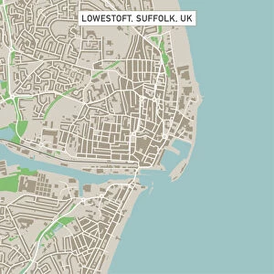
Murrieta California US City Street Map

![]()
Wall Art and Photo Gifts from Fine Art Storehouse
Murrieta California US City Street Map
Vector Illustration of a City Street Map of Murrieta, California, USA. Scale 1:60, 000.
All source data is in the public domain.
U.S. Geological Survey, US Topo
Used Layers:
USGS The National Map: National Hydrography Dataset (NHD)
USGS The National Map: National Transportation Dataset (NTD)
Unleash your creativity and transform your space into a visual masterpiece!
Frank Ramspott
Media ID 15055055
© Frank Ramspott, all rights reserved
Aerial View California City Map Computer Graphic Directly Above Downtown District Gray Road Map Text Digitally Generated Image Green Color White Color
FEATURES IN THESE COLLECTIONS
> Aerial Photography
> Related Images
> Animals
> Insects
> Hemiptera
> Green Scale
> Animals
> Mammals
> Cricetidae
> California Mouse
> Arts
> Contemporary art
> Digital artwork
> Street art
> Arts
> Landscape paintings
> Waterfall and river artworks
> River artworks
> Arts
> Portraits
> Pop art gallery
> Street art portraits
> Arts
> Street art graffiti
> Digital art
> Digital paintings
> Arts
> Street art graffiti
> Digital art
> Vector illustrations
> Fine Art Storehouse
> Map
> Street Maps
> Fine Art Storehouse
> Map
> USA Maps
> Maps and Charts
> Geological Map
> Maps and Charts
> Related Images
EDITORS COMMENTS
This print showcases a meticulously designed city street map of Murrieta, California. With its intricate details and precision, the vector illustration provides an accurate representation of the city's layout. The scale of 1:60,000 ensures that every street and landmark is clearly depicted. The source data used to create this masterpiece is in the public domain, courtesy of U. S. Geological Survey's National Hydrography Dataset (NHD) and National Transportation Dataset (NTD). These reliable sources guarantee the authenticity and accuracy of the map. The image captures Murrieta's downtown district with its charming streets winding alongside a serene river and lake. The vibrant colors - shades of gray, green, blue, and white - bring life to this digitally generated artwork. With no people present in the picture, all attention is drawn to the intricacy of cartography displayed here. This aerial view from directly above allows viewers to appreciate both the physical geography and urban design elements incorporated into this visually stunning piece. Frank Ramspott deserves recognition for his skillful creation as he successfully combines technology with artistry to produce a unique representation of Murrieta's cityscape. Whether you are a resident or simply fascinated by maps, this print will undoubtedly captivate your imagination with its beauty and attention to detail.
MADE IN THE USA
Safe Shipping with 30 Day Money Back Guarantee
FREE PERSONALISATION*
We are proud to offer a range of customisation features including Personalised Captions, Color Filters and Picture Zoom Tools
SECURE PAYMENTS
We happily accept a wide range of payment options so you can pay for the things you need in the way that is most convenient for you
* Options may vary by product and licensing agreement. Zoomed Pictures can be adjusted in the Cart.