Home > Europe > United Kingdom > England > Nottinghamshire > Nottingham
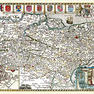
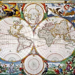
Old County Map of Nottinghamshire 1648 by Johan Blaeu from the Atlas Novus

![]()
Wall Art and Photo Gifts from MapSeeker
Old County Map of Nottinghamshire 1648 by Johan Blaeu from the Atlas Novus
This detailed and most attractive reproduction map of Nottinghamshire has been carefully art worked from a scan of an antique original. The famous firm of Dutch cartographers and publishers was established in the late 16th century by Willem Janszoon Blaeu in Amsterdam. Blaeu was a maker of globes and scientific instruments and purchased some of his early map plates from Jodocus Hondius. From this small beginning was to emerge one of the largest and most prolific map publishing houses of the seventeenth century
Welcome to the Mapseeker Image library and enter an historic gateway to one of the largest on-line collections of Historic Maps, Nostalgic Views, Vista's and Panorama's from a World gone by.
Media ID 20347677
Blaeu Blaeu Family Blaue Map County Map County Map Of England English County Map Historic Map Johan Blaeu Johan Blaeu Map Old Blaue Map Old County Map Old English County Map Nottinghamshire
FEATURES IN THESE COLLECTIONS
> Arts
> Artists
> B
> Willem Blaeu
> Arts
> Artists
> H
> Jodocus Hondius
> Arts
> Photorealistic artworks
> Detailed art pieces
> Masterful detailing in art
> Europe
> United Kingdom
> England
> Maps
> Europe
> United Kingdom
> England
> Nottingham
> Europe
> United Kingdom
> England
> Nottinghamshire
> Nottingham
> Europe
> United Kingdom
> England
> Nottinghamshire
> Related Images
> Maps and Charts
> Early Maps
> Maps and Charts
> Willem Janszoon Blaeu
> MapSeeker
> Maps from the British Isles
> England and Counties PORTFOLIO
EDITORS COMMENTS
This beautifully crafted reproduction of the "Old County Map of Nottinghamshire 1648" by Johan Blaeu takes us back in time to explore the historical landscape of this English county. Carefully art worked from a scan of an antique original, this detailed and attractive map showcases the expertise and craftsmanship that made the Dutch cartographers and publishers, Blaeu family, renowned during the seventeenth century. Established by Willem Janszoon Blaeu in Amsterdam, their journey began with globe-making and scientific instruments before expanding into map publishing. The firm's early map plates were acquired from Jodocus Hondius, setting them on a path to become one of the largest and most prolific map publishing houses at that time. The intricate details captured in this old English county map allow us to trace Nottinghamshire's rich history. From its charming towns and villages to its sprawling countryside, every corner is meticulously depicted. This historic piece serves as a valuable resource for researchers, historians, or anyone fascinated by Nottinghamshire's past. Whether you are exploring your ancestral roots or simply appreciating the beauty of cartographic artistry, this reproduction offers a glimpse into Nottinghamshire's heritage like never before. Let yourself be transported back centuries as you immerse yourself in this depiction of one of England's beloved counties - Nottinghamshire.
MADE IN THE USA
Safe Shipping with 30 Day Money Back Guarantee
FREE PERSONALISATION*
We are proud to offer a range of customisation features including Personalised Captions, Color Filters and Picture Zoom Tools
SECURE PAYMENTS
We happily accept a wide range of payment options so you can pay for the things you need in the way that is most convenient for you
* Options may vary by product and licensing agreement. Zoomed Pictures can be adjusted in the Cart.